Hest bank jetty
Hest bank jetty (82451)
- Easting
- 346844
- Northing
- 466787
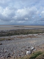
Early 19th-century stone jetty n/s alignment west side badly eroded upright timbers on outside of structure eastern side kerr channel moved further out since 2004
- Period
- Post-Medieval (1540 - 1901)
- Period comments
known cargo jetty for hest bank canal company 1819 -18 31 before trade moved to Glasson dock
- The earliest date of the feature, as a year, if known
- 1800
- The latest date of the feature, as a year, if known
- 1850
- Monument Type - Broad
- Landing point
- Monument Type - Narrow
- Jetty
- Monument Description
- A mole or pier-like structure situated at the entrance of a harbour, or running out into lake or the sea, so as to defend the harbour or coast.
- Evidence Type - Broad
- Evidence Type - Narrow
- Evidence Description
- Object Type - Broad
- Object Type - Narrow
- Object Description
- Height OD (m)
- How accessible is the feature?
- Accessible - difficult terrain
- Accessibility comments
weather dependent tidal shifting sands
Other records:
- NRHE Number
- Unknown
- NT HBSMR Number
- Unknown
- HER Event Number
- Unknown
- External Link
- None
Over to you...
If you know there are errors in the original feature record above, you can edit the original record
If you would like to visit the feature and carry out a 'Feature Update Survey', you can prepare a 'Feature Update Survey' pack for this feature (in PDF format)
If you have completed a 'Feature Update Survey' for this feature, you can submit your 'Feature Update Survey'
If you want to use your smart phone to carry out the 'Feature Update Survey', you can download the CITiZAN smart app.
Feature Update Surveys
1 survey accepted and 0 pending.
Click on a survey to expand it.
- Date of survey
- 22nd March, 2017
- Feature located?
- Yes
- State of the tide
- Low
- Proximity to coast edge
- Intertidal zone
- Coastal processes
- Active sea erosion, Has eroded in the past, Accreting
- Is there a coastal defence?
- Other threats?
- Visitor erosion, Structural damage/decay, Water erosion (e.g. stream, etc)
- If other, please specify
- How visible are the remains? ABOVE GROUND
- Limited visibility (partial remains)
- How visible are the remains in the face of the cliff, ridge or dune? IN SECTION
- Limited visibility in section
- Do you know if the feature is?
- Has local associations/history
- What actions (if any) would you recommend for this feature?
citizan /Morecambe Bay partnership monitoring
- Do you have any other comments?
channels are constantly changing
Photos