Clay Shafts
Clay Shafts (82942)
- Easting
- 401839
- Northing
- 88557
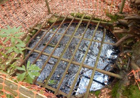
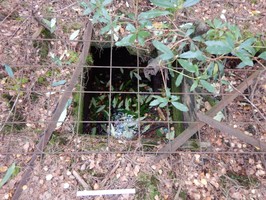
Eight clay shafts are located around the area of Seymers Marsh on the north coast of Brownsea Island. The three most easterly shafts are visible above ground as upstanding brick lined circular shafts. The remaining are at ground level and as such have been cordoned off by the Dorset Wildlife Trust who manage the land, all are circular and brick lined except one which is square and timber lined. They were constructed in the 1850's when the island was owned by Colonel William Waugh, they were used to prospect for clay - specifically the local 'ball clay', a very fine white clay capable of being fired at extremely high temperatures and producing fine tablewares, at the time the fashion for tea drinking meant that fine tea sets were in high demand and such clay was highly sought after. However, the quantities on Brownsea were not sufficient to sustain an industry and instead a less fine clay was used to produce domestic wares including drainage pipes. The clay was transported from the shafts across to the pottery works on the south west coast of the island via a tramway, possible remains of this are also visible at Seymers.
- Period
- Post-Medieval (1540 - 1901)
- Period comments
Constructed in the 1850's
- The earliest date of the feature, as a year, if known
- The latest date of the feature, as a year, if known
- Monument Type - Broad
- Industrial site
- Monument Type - Narrow
- Monument Description
- Evidence Type - Broad
- Structure
- Evidence Type - Narrow
- Extant
- Evidence Description
- Man-made roofless edifice or construction which is intact or substantially intact, with significant survival of original features, even if no longer serving original intended function.
- Object Type - Broad
- Object Type - Narrow
- Object Description
- Height OD (m)
- How accessible is the feature?
- Not accessible, but visible from public path/road/adjacent land
- Accessibility comments
The shafts are located within the Dorset Wildlife Trust conservation area so the site is only accessible with permission from the warden.
Other records:
- NRHE Number
- Unknown
- NT HBSMR Number
- Unknown
- HER Event Number
- Unknown
- External Link
- None
Over to you...
If you know there are errors in the original feature record above, you can edit the original record
If you would like to visit the feature and carry out a 'Feature Update Survey', you can prepare a 'Feature Update Survey' pack for this feature (in PDF format)
If you have completed a 'Feature Update Survey' for this feature, you can submit your 'Feature Update Survey'
If you want to use your smart phone to carry out the 'Feature Update Survey', you can download the CITiZAN smart app.
Feature Update Surveys
1 survey accepted and 0 pending.
Click on a survey to expand it.
- Date of survey
- 13th November, 2017
- Feature located?
- Yes
- State of the tide
- Mid
- Proximity to coast edge
- Intertidal zone
- Coastal processes
- Active sea erosion
- Is there a coastal defence?
- No
- Other threats?
- Structural damage/decay
- If other, please specify
- How visible are the remains? ABOVE GROUND
- Highly visible (substantial remains)
- How visible are the remains in the face of the cliff, ridge or dune? IN SECTION
- Do you know if the feature is?
- Has local associations/history
- What actions (if any) would you recommend for this feature?
Continued monitoring of the shafts as the upstanding three are clearly deteriorating.
- Do you have any other comments?
There are eight shafts in total as well as evidence of cutting into the cliffs to extract clay, there is also possible evidence of the tramway. The site would benefit from continued monitoring by wardens and volunteers of the Dorset Wildlife Trust.
Two are on the waters edge and the remaining are withing 20 metres of the coast edge.
Photos
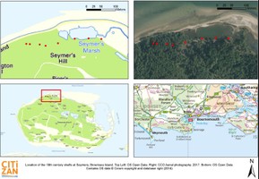
Seymers shaft locations by LTidbury
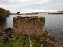
Upstanding brick lined clay shaft by LTidbury
Square wood lined shaft by LTidbury