Hulk of WW2 landing craft, possibly LCA or LCVP.
Hulk of WW2 landing craft, possibly LCA or LCVP. (82023)
- Easting
- 628602
- Northing
- 250171
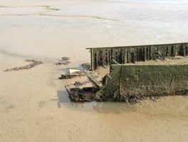
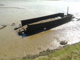
Remains of a rectangular, box shaped, vessel similar in shape, internal layout and approximate size to World War 2 small landing craft such as LCA (landing craft assault) or LCVP (landing craft vehicle/personell). The stern section has almost entirely collapsed as has the bow / ramp. The feature gets a passing mention amongst other riverside hulks and the remains of pleasure craft in the 2012 rapid survey but is not identified specifically.
A part of MSF20650 http://www.heritagegateway.org.uk/Gateway/Results_Single.aspx?resourceID=1017&uid=MSF20650
Feature update (14.01.2022) C. Kolonko-
Unlikely to be a Second World War landing craft. Hull sides are too steep for an LCVP and certainly not an LCA according to landing craft specialist Stephen Fisher.
Source-
Pers. Comms. S. Fisher (12.01.2022)
- Period
- Modern (1901 and later)
- Period comments
Appears to be a landing craft of a style built in the 1940's for use in World War 2.
- The earliest date of the feature, as a year, if known
- The latest date of the feature, as a year, if known
- Monument Type - Broad
- Wreck
- Monument Type - Narrow
- Monument Description
- The remains of a vessel, which has either sunk or suffered structural damage to the extent where it can no longer function.
- Evidence Type - Broad
- Vessel
- Evidence Type - Narrow
- Collapsed
- Evidence Description
- A maritime monument where the fabric of a vessel has collapsed, leaving the hull structure flat on the seabed but not widely dispersed.
- Object Type - Broad
- Object Type - Narrow
- Object Description
- Height OD (m)
- How accessible is the feature?
- Not accessible, but visible from public path/road/adjacent land
- Accessibility comments
The feature is visible from the river walk approximately 400 metres from Melton railway station. Car parking is available and free beside the river walk just east of the station. Although the feature itself is only 4 or 5 metres from the river wall it is inaccessible due to the steepness of the riverwall and the unknown dept of mud. The feature is only fully visible at low tide.
Other records:
- NRHE Number
- Unknown
- NT HBSMR Number
- Unknown
- HER Event Number
- MSF20650
- External Link
- None
Over to you...
If you know there are errors in the original feature record above, you can edit the original record
If you would like to visit the feature and carry out a 'Feature Update Survey', you can prepare a 'Feature Update Survey' pack for this feature (in PDF format)
If you have completed a 'Feature Update Survey' for this feature, you can submit your 'Feature Update Survey'
If you want to use your smart phone to carry out the 'Feature Update Survey', you can download the CITiZAN smart app.
Feature Update Surveys
2 surveys accepted and 0 pending.
Click on a survey to expand it.
- Date of survey
- 24th September, 2016
- Feature located?
- Yes
- State of the tide
- Low
- Proximity to coast edge
- Intertidal zone
- Coastal processes
- Active sea erosion
- Is there a coastal defence?
- Yes
- Other threats?
- If other, please specify
- How visible are the remains? ABOVE GROUND
- Limited visibility (partial remains)
- How visible are the remains in the face of the cliff, ridge or dune? IN SECTION
- Do you know if the feature is?
- Don't know
- What actions (if any) would you recommend for this feature?
- Do you have any other comments?
- Date of survey
- 7th October, 2016
- Feature located?
- Yes
- State of the tide
- Low
- Proximity to coast edge
- Intertidal zone
- Coastal processes
- Active sea erosion
- Is there a coastal defence?
- Yes
- Other threats?
- If other, please specify
- How visible are the remains? ABOVE GROUND
- Limited visibility (partial remains)
- How visible are the remains in the face of the cliff, ridge or dune? IN SECTION
- Do you know if the feature is?
- Don't know
- What actions (if any) would you recommend for this feature?
Further local enquiries to seek earlier photographic evidence of the vessel in a better and hopefully more recognisable condition, and to get any anecdotal information from local boatyard workers, riverside dwellers, boatmen etc as to their memories of the vessel's previous ownership, history, mooring locations etc.
- Do you have any other comments?
Recorded with the Marine Antiquities Service https://marinefinds.org.uk/database/artefacts/record/id/12 as a probable minor landing craft assault.
Photos
View towards the bow section by Geelan
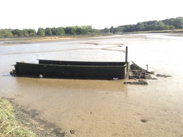
The stern section by Geelan
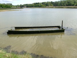
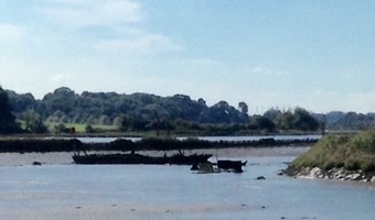
The vessel at high tide by Geelan
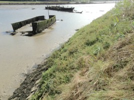
View bow to stern by Geelan