Defending the coast at Reighton Sands
03/08/2018 | Chris Kolonko
My name is Chris Kolonko and I’ve just joined the CITiZAN North team. I specialise in the archaeology of First and Second World War defences in the UK, especially defences dating from the invasion scare period of 1940 to 1943.
I spend much of my time researching, recording and interpreting surviving Coastal Crust defences from the Second World War, which is rather useful when it comes to CITiZAN.
There is still a lot we can learn from our surviving wartime defences and this blog will look at some of the things archaeologists can do to interpret surviving wartime defences.
Wartime defences
Wartime coastal defences are particularly vulnerable to coastal erosion, with many surviving examples being damaged or destroyed on a yearly basis. It is extremely important that surviving defences are properly recorded and interpreted before they are lost. Doing so will help to preserve these sites in the record once they have been destoyed.
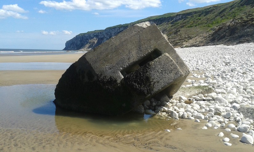
What survives today represents only a small fraction of the original defensive network constructed from 1940 onwards. Many defences were cleared towards the end of the war and during the post-war period. This has also led to an over representation of concrete defences (pillboxes, anti-tank obstacles and anti-tank gun positions) in current records. Many of the more ephemeral defences; such as trenches, barbed wire obstacle and roadblocks tend to be completely overlooked, although they were an important aspect of the 1940s defensive landscape.
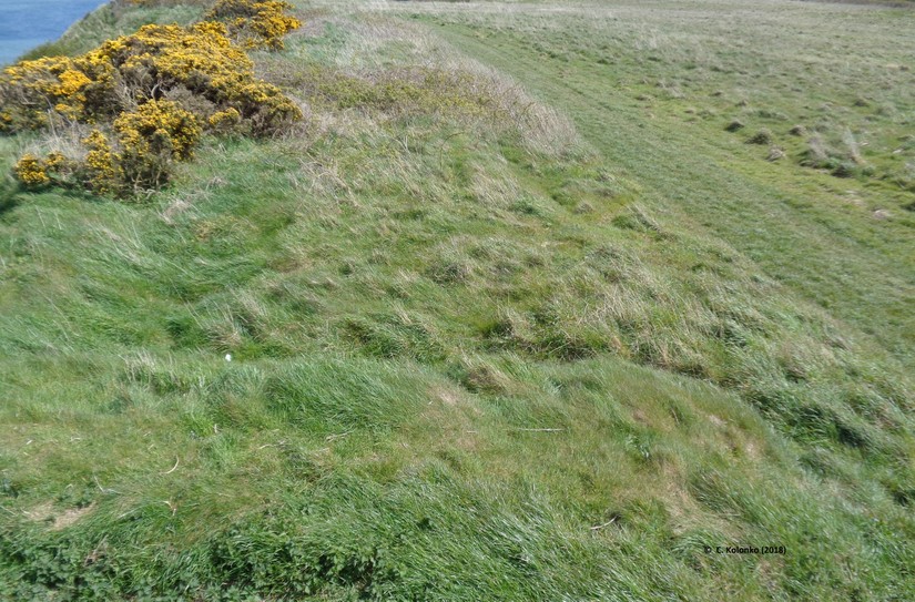
One area I am particularly interested in is the beach at Reighton Sands, North Yorkshire. This stretch of beach was once one of the most heavily fortified locations on the Yorkshire coast. However, much of Reighton’s defences have been destroyed or damaged by coastal erosion, and many ephemeral remains remain un-discovered and un-recorded.
Aerial photographs
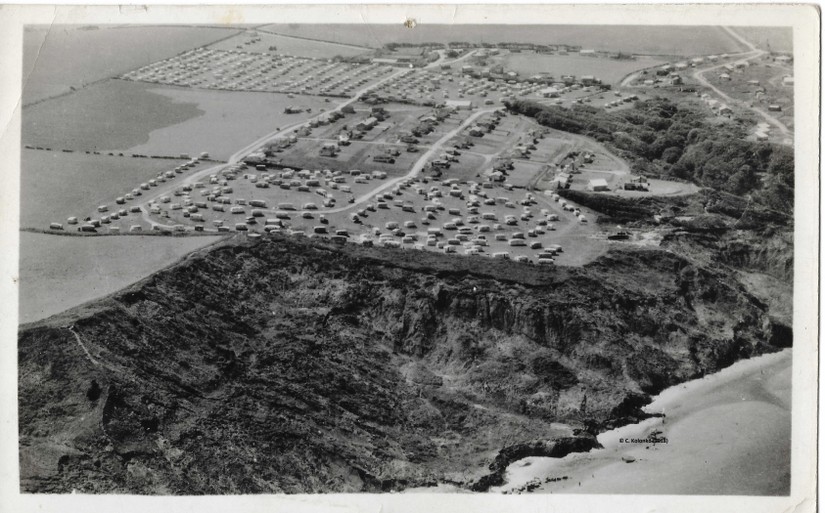
Luckily, there are some resources we can use to identify lost defences. Aerial photographs taken during the war are great for identifying and mapping lost wartime defences- often revealing barbed wire obstacles, road blocks and trenches. All of which rarely survived the peace time clearances.
Postcards are also a great resource for identifying wartime defences (and other forms of coastal archaeology), especially when the images were taken during or shortly after the end of the war.
Using aerial photographs and postcards has allowed me to map the whole defensive network at Reighton, creating a more detailed picture of what was constructed during the war. This is really useful as I can use these results to determine the defensive strategy; highlighting which areas and landscape features were deemed strategically important to the defenders.
This information can then be used during fieldwork to identify and record surviving features on the ground and assess their condition.
Further interpretation
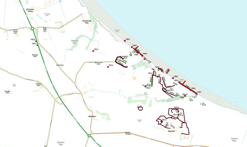
It is also possible to go one step further with the information gathered. Plotting active defences, such as pillboxes, into a GIS programme (a piece of software a bit like the CITiZAN recording app); we can start to look at the relationships between fixed defences in the landscape; especially those that would have housed weapons. Doing so helps to explain why and how the pillboxes were defensively sited within the landscape.
By plotting each pillbox’s arcs of fire and weapon ranges it is possible to build up a picture of the area each pillbox could cover with fire. We can also investigate which features the pillboxes were sited to defend, such as important beach exits, river crossings or road junctions.
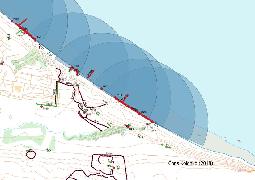
The image below shows the arcs of fire for beach front ‘eared’ pillboxes at Reighton Sands. Each of these pillboxes was capable of housing a pair of Vickers Medium Machine Guns and their crews. These pillboxes were sited to pour withering fire down the length of the beach, covering the front of adjacent pillboxes on the beach. This would have made crossing the beach very hazardous to any enemy infantry landing in the area. The secondary line of pillboxes and trenches located on the cliff top were also able to pour fire down onto the beach; essentially creating a pre-prepared kill-zone of deadly fire on the beach.
Conclusion
Applying these methods to Coastal Crust defences is great for helping us to visualise how the coast would have been defended had the Wehrmacht (German Army) landed during the 1940s.
Similar methods can also be applied to coastal artillery batteries, searchlight emplacements and trenches.
Plotting arcs of fire has been used to great affect at Auburn Sands, where this method led to the rediscovery of at least one buried pillbox.
There is still a lot we can learn about the defensive landscapes of the First and Second World Wars. Recent coastal erosion and shifting sands still reveals many unrecorded defences; all of which can be recorded through CITiZAN.
Why not record the defences you find when visiting the coast? Think about how the defences would have been used to fend off enemy soldiers landing on the beach and consider that today’s survivors were once part of a much wider defensive network.