A Roman Trackway in Calshot
01/03/2018 | Lauren Tidbury
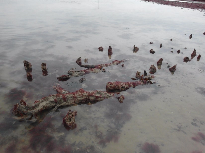
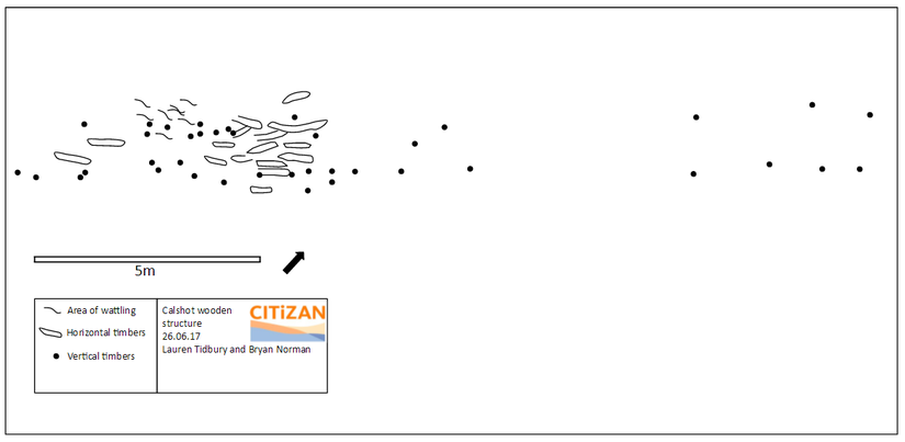
In February 2015 during an extreme low spring tide a member of the public noticed a wooden structure protruding from the beach at Calshot in Hampshire. They contacted the Maritime Archaeology Trust (MAT) based in Southampton who undertook a preliminary photographic survey. Staff and volunteers from CITiZAN then visited the site in 2017 to take more photographs of the feature, together with a detailed rapid offset survey to create the first measured site plan (see below). This work was followed up with a series of regular monitoring visits.
The structure consists of two rows of approximately 35 vertical timbers varying in diameter from 5-20cm which runs parallel to the current shoreline. Between the upright timbers are a number of horizontal timbers as well as possible wattling, suggesting that the feature may represent the remains of a timber trackway. It is only exposed on an extreme low spring tide and only for around 30 minutes. The timbers protrude from a layer of grey clay, surrounded by a sandy shingle bank. The hollow is approximately 20 metres across, however, later visits have shown some more timbers protruding above the sandy shingle to the east and west which, if all part of the same structure, suggests it could be at least 70-80m in length.
During the first visit the feature was fully exposed by the tide, however, during subsequent visits even on an extreme low tide there was still around 10cm of water covering the base of the feature. This may be due to some scouring around the site and a build-up of the shingle bank, causing the feature to be located in a depression so even on the lowest of tides it is no longer fully exposed. Although this situation is helping with the preservation of these fragile remains, it makes continued work on the site more difficult.
The next step was to try to date the feature. It’s location in relation to the current shoreline and sea level suggests that it could be of some antiquity, therefore after CITiZAN took advice from Historic England, samples were taken and sent off for radiocarbon dating. Results have shown that the feature dates to 1864 - 1708 cal BP, that is most probably between 86 - 242 cal AD. There is little other evidence from the Roman period along this coast and not much is known about what the contemporary coastline would have looked like, but it is possible that this was a trackway built to cross a marshy environment at a time when the shoreline was several hundred metres further out than it is today.
The Solent would have been an important area during the Roman period, not only allowing for trade along the coast and across the Channel but also in the exploitation of marine resources such as salt and fish. Calshot lies at the entrance to Southampton water and significant Roman sites have been found in this area, particularly at Bitterne which is thought may have been a key port during this period (Hampshire HER: Atlas of Hampshire’s Archaeology). Other Roman sites nearby include a Roman road which is thought to have run from Dibden to Lepe beach, possibly then with ferry connections to the Isle of Wight.
Was our trackway therefore part of an industrial landscape, allowing for the exploitation of marine resources or for the production of salt? What was the environment like during this time, and what can this tell us about the Solent during the Roman period? More work is required to answer these questions and the CITiZAN project plans to undertake further work on the feature in collaboration with the New Forest National Park Authority and the Maritime Archaeology Trust. In the meantime, the site will continue to be monitored, since the fragile remains are exposed and at risk of being damaged or destroyed by extreme weather, making further work to understand the site and its context all the more important.