FLOATING ROADWAY
FLOATING ROADWAY (25165)
- Easting
- 333775
- Northing
- 390383
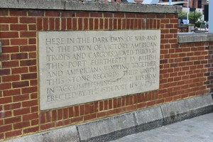
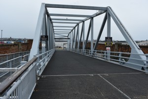
The Floating Roadway was built 1872-74 between Princes Dock and George's Dock to provide shallow-grade access to the Liverpool landing stage; it allowed road vehicles on to the landing stage, so they can be carried by ferry to Birkenhead or Seacombe on the Wirral side of the river. The roadway was fixed at the east end at ground level and attached at the west end to the landing stage, which rose and fell with the tide. Its retaining walls on the north and south sides were later extended to provide new river walls, and after World War II were partly rebuilt in brick and a memorial was added to the south side of the south wall to commemorate the American Transport operations during the war.
- Period
- Post-Medieval (1540 - 1901)
- Period comments
Post World War II|1872-74
- The earliest date of the feature, as a year, if known
- 1872|1946
- The latest date of the feature, as a year, if known
- 1874|1946
- Monument Type - Broad
- FLOATING ROADWAY|WAR MEMORIAL (TRIBUTE)|REVETMENT
- Monument Type - Narrow
- Monument Description
- Evidence Type - Broad
- Evidence Type - Narrow
- Evidence Description
- Object Type - Broad
- Object Type - Narrow
- Object Description
- Height OD (m)
- How accessible is the feature?
- Accessible on foot (footpath)
- Accessibility comments
Other records:
- NRHE Number
- 1431299
- NT HBSMR Number
- Unknown
- HER Event Number
- Unknown
- External Link
- None
Over to you...
If you know there are errors in the original feature record above, you can edit the original record
If you would like to visit the feature and carry out a 'Feature Update Survey', you can prepare a 'Feature Update Survey' pack for this feature (in PDF format)
If you have completed a 'Feature Update Survey' for this feature, you can submit your 'Feature Update Survey'
If you want to use your smart phone to carry out the 'Feature Update Survey', you can download the CITiZAN smart app.
Feature Update Surveys
1 survey accepted and 0 pending.
Click on a survey to expand it.
- Date of survey
- 29th May, 2019
- Feature located?
- Yes
- State of the tide
- Proximity to coast edge
- Coastal processes
- Is there a coastal defence?
- Other threats?
- If other, please specify
- How visible are the remains? ABOVE GROUND
- How visible are the remains in the face of the cliff, ridge or dune? IN SECTION
- Do you know if the feature is?
- Is well known, Has local associations/history
- What actions (if any) would you recommend for this feature?
- Do you have any other comments?