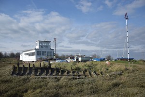
MALDON LEISURE CENTRE HULK ASSEMBLAGE (aka the Barge Graveyard, Promenade Park)
MALDON LEISURE CENTRE HULK ASSEMBLAGE (aka the Barge Graveyard, Promenade Park) (34900)
- Easting
- 586400
- Northing
- 206300
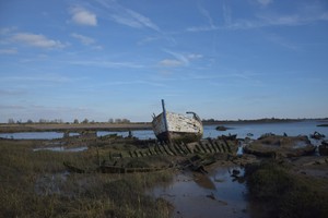
Assemblage of approximately 15 hulked barges located to the east of Maldon Leisure Centre. Some may have been recorded in a survey of 1987.
- Period
- Modern (1901 and later)
- Period comments
Some hulked by 1987, some may be later (see any other comments, below)
- The earliest date of the feature, as a year, if known
- 1987
- The latest date of the feature, as a year, if known
- 2011
- Monument Type - Broad
- SHIP GRAVEYARD|WRECK
- Monument Type - Narrow
- Monument Description
- Evidence Type - Broad
- Evidence Type - Narrow
- Evidence Description
- Object Type - Broad
- Object Type - Narrow
- Object Description
- Height OD (m)
- How accessible is the feature?
- Accessible - difficult terrain, Accessible on foot (footpath)
- Accessibility comments
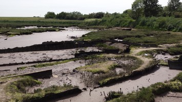
Accessible via an informal pathway which can be very slippery
Other records:
- NRHE Number
- 1526636
- NT HBSMR Number
- Unknown
- HER Event Number
- Unknown
- External Link
- None
Over to you...
If you know there are errors in the original feature record above, you can edit the original record
If you would like to visit the feature and carry out a 'Feature Update Survey', you can prepare a 'Feature Update Survey' pack for this feature (in PDF format)
If you have completed a 'Feature Update Survey' for this feature, you can submit your 'Feature Update Survey'
If you want to use your smart phone to carry out the 'Feature Update Survey', you can download the CITiZAN smart app.
Feature Update Surveys
2 surveys accepted and 0 pending.
Click on a survey to expand it.
- Date of survey
- 5th April, 2016
- Feature located?
- Yes
- State of the tide
- Proximity to coast edge
- Coastal processes
- Active sea erosion
- Is there a coastal defence?
- No
- Other threats?
- Structural damage/decay
- If other, please specify
- How visible are the remains? ABOVE GROUND
- Highly visible (substantial remains)
- How visible are the remains in the face of the cliff, ridge or dune? IN SECTION
- Do you know if the feature is?
- Is well known, Has local associations/history
- What actions (if any) would you recommend for this feature?
Recording and monitoring: The East of England archaeological research framework states that “a survey of the shipwrecks along the estuaries, coast and offshore is needed. The survey should be coupled with historic research and cross-reference to records of groups such as the Society for Sailing Barges”.
- Do you have any other comments?
The site is well known locally and referred to as 'the Barge Graveyard'.
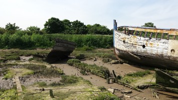
The assemblage includes four vessels listed (with further information) in Essex HER <1>: MEX37960: Wreck of Thames Barge British Lion, built Rochester 1879 MEX37964: Thames Barge wreck Mamgu (ex Cawana), built 1904 MEX37968: Thames barge wreck Pretoria, built at Faversham 1902 MEX37971: Thames barge wreck William Cleverly, built Rochester 1899
as well as the remains of: Thames barge Vicunia, built Greenwich 1912 The stern of Thames barge Lady Helen, built Rochester 1902 Goldfinch (a lighter) A steel mooring pontoon A Belgian (possibly Scandinavian built) fishing vessel A fishing vessel An ex Admiralty launch <2> <3><4><5>
Historic aerial photography indicates that the Belgian (possibly Scandinavian built) fishing vessel was deposited at the site between 31.12.2009 and 07.03.2011 <6>
Sources: <1> http://www.heritagegateway.org.uk/ [Accessed 05.04.2016] <2> Society for Spritsail Barge Research, 1987, The Last Berth of the Sailorman <3> Colin Swindale (pers. comm., email 18.08.2015) <4> Barry Pearce, 1995, Notes on wrecks in the Blackwater and Chelmer written for the Society for Spritsail Barge Research [Accessed via Maldon Tourist Information Centre, July 2015] <5> Alan Williams (pers. comm., site visit 08.06.2015) <6> Google Earth [Accessed 05.04.2016]
- Date of survey
- 19th April, 2016
- Feature located?
- Yes
- State of the tide
- Low
- Proximity to coast edge
- Coastal processes
- Active sea erosion
- Is there a coastal defence?
- No
- Other threats?
- If other, please specify
- How visible are the remains? ABOVE GROUND
- Highly visible (substantial remains)
- How visible are the remains in the face of the cliff, ridge or dune? IN SECTION
- Do you know if the feature is?
- Is well known
- What actions (if any) would you recommend for this feature?
- Do you have any other comments?
In February 2016 high tides caused the upper part of the side of one of the unknown fishing vessel (which lies directly to the west of the Belgian, possibly Scandinavian built, fishing vessel) to sheer off and float away. It was found by members of Maldon Yacht Club, which lies just to the north of the site, knocking into the side of their club. They dragged it onto the salt marsh and tethered it there to prevent further damage to the club.
Photos

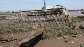
Damage to the unknown fishing vessel by LBand
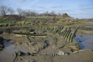
Damage to the unknown fishing vessel by LBand