UB-122
UB-122 (59422)
- Easting
- 583054
- Northing
- 173471
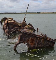
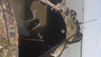
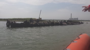
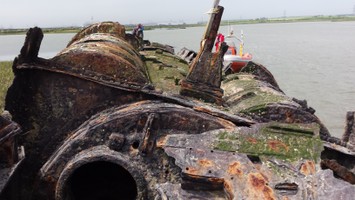
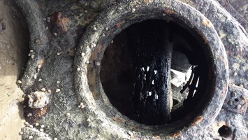
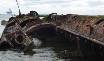
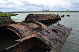
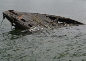
The remains of a surrendered First World War German U-boat beached in the inter-tidal zone to the west of Humble Bee creek in Stoke Saltings, after being broken up locally in 1921 or 1922. Various candidates have been suggested, including U 122 and U 123; UB 76, UB 93, UB 122, UB 144, UB 145, and UB 150. The wreck in the Medway measures circa 50m, more consistent with the dimensions of a UB type vessel than a U type. The identity most persistently suggested for this vessel is the remains of UB 122, which, however, was recorded at Portsmouth for sinking in deep water in 1921. This wreck can be seen on aerial photographs taken in 1946 and was still visible in 2011. It was mapped from aerial photographs as part of the English Heritage: Hoo Peninsula Landscape Project. A neighbouring wreck is the remains of the SWALE, recorded at 1538287. This is a really significant site. Although this particular U-boat probably did not see active service (it was probably completed just before the Armistice, or afterwards), it is an example of the most numerous class of U-boats which had a profound impact on Allied and neutral shipping and seafarers in 1917-18. This example was hulked after being partly scrapped, but UB III class U-boats were active in the North Sea and so the wreck is still, to a degree, 'in context'. As it is in the intertidal zone this U-boat is relatively accessible compared to other examples that are submerged, especially in terms of visualisation by the public. The remains of the U-boat are substantial even though major components have been removed; the decayed condition of the wreck makes it possible to see details of how U-boats were constructed.
- Period
- Modern (1901 and later)
- Period comments
Lost after surrender 1921
- The earliest date of the feature, as a year, if known
- 1921
- The latest date of the feature, as a year, if known
- 1921
- Monument Type - Broad
- Wreck
- Monument Type - Narrow
- Monument Description
- The remains of a vessel, which has either sunk or suffered structural damage to the extent where it can no longer function.
- Evidence Type - Broad
- Evidence Type - Narrow
- Evidence Description
- Object Type - Broad
- Object Type - Narrow
- Object Description
- Height OD (m)
- How accessible is the feature?
- Accessibility comments
Other records:
- NRHE Number
- 900735
- NT HBSMR Number
- Unknown
- HER Event Number
- Unknown
- External Link
- None
Over to you...
If you know there are errors in the original feature record above, you can edit the original record
If you would like to visit the feature and carry out a 'Feature Update Survey', you can prepare a 'Feature Update Survey' pack for this feature (in PDF format)
If you have completed a 'Feature Update Survey' for this feature, you can submit your 'Feature Update Survey'
If you want to use your smart phone to carry out the 'Feature Update Survey', you can download the CITiZAN smart app.
Feature Update Surveys
2 surveys accepted and 0 pending.
Click on a survey to expand it.
- Date of survey
- 6th June, 2016
- Feature located?
- Yes
- State of the tide
- Mid
- Proximity to coast edge
- Intertidal zone
- Coastal processes
- Active sea erosion
- Is there a coastal defence?
- Other threats?
- Structural damage/decay
- If other, please specify
- How visible are the remains? ABOVE GROUND
- Highly visible (substantial remains)
- How visible are the remains in the face of the cliff, ridge or dune? IN SECTION
- Do you know if the feature is?
- Is well known, Has local associations/history
- What actions (if any) would you recommend for this feature?
- Do you have any other comments?
- Date of survey
- 3rd August, 2016
- Feature located?
- Yes
- State of the tide
- Low
- Proximity to coast edge
- Intertidal zone
- Coastal processes
- Not eroding
- Is there a coastal defence?
- No
- Other threats?
- Structural damage/decay, Other
- If other, please specify
- Corrosion of metal leading to collapse
- How visible are the remains? ABOVE GROUND
- Highly visible (substantial remains)
- How visible are the remains in the face of the cliff, ridge or dune? IN SECTION
- Do you know if the feature is?
- Is well known
- What actions (if any) would you recommend for this feature?
- Detailed recording of current condition as baseline for subsequent monitoring.
- Further historical research to resolve identification and provide further context.
- Make available interpretation materials online; the U-boat is quite widely known and believed to be UB-122, so information should be made available to temper this apparent mis-identification.
- Do you have any other comments?
This is a really significant site. Although this particular U-boat probably did not see active service (it was probably completed just before the Armistice, or afterwards), it is an example of the most numerous class of U-boats which had a profound impact on Allied and neutral shipping and seafarers in 1917-18. This example was hulked after being partly scrapped, but UB III class U-boats were active in the North Sea and so the wreck is still, to a degree, 'in context'. As it is in the intertidal zone this U-boat is relatively accessible compared to other examples that are submerged, especially in terms of visualisation by the public. The remains of the U-boat are substantial even though major components have been removed; the decayed condition of the wreck makes it possible to see details of how U-boats were constructed.
Photos
UB-122 by OHutchinson
UB-122 by OHutchinson
UB-122 by OHutchinson
UB-122 by OHutchinson
Medway U-boat looking forward by Fjordr
Medway U-boat looking aft by Fjordr
Medway U-boat - bow section by Fjordr